Google Maps Delivering Live Public-Transit Info
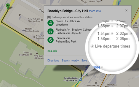
Offering your audience a set of static maps on their smartphone is certainly impressive, when you consider the engineering and infrastructure involved (not to mention the cost of buying all that satellite imagery). But it’s also very 2008. These days, people want their map apps continually updated with live information, especially traffic and public transportation. To that end, Google is offering a small program involving seven lines of the New York City subway (MTA), as well as buses and trams for Salt Lake City (the UTA). Google Maps will now offer live updates on departure times for both those systems. And that’s not all. “Riders on the nation’s second largest subway, Metrorail in Washington, D.C., can now see live service alerts,” mentioned the Google Lat Long blog in a March 27 posting, “including unplanned delays and scheduled track work, straight from Metro’s Control Center on Google Maps.” Google Maps already offers transit information for 800 cities in 25 countries, including pick-up locations and estimated travel time. But it’s another thing entirely to incorporate live data for buses or subways trundling their merry way through traffic. Google already offers live traffic data for select cities around the world, an imminently useful tool for commuters who just want to avoid that snarled interchange or unexpectedly blocked two-lane road; adding public transportation could make its Maps app that much more valuable. While Google Maps are held in high regard by millions, the company faces growing competition in the cartographical realm from Apple, Nokia, and other well-funded tech companies. Rumors over the past few months suggest that Apple is snatching up a number of mapping startups in order to improve its own much-criticized Maps app; earlier this week, The Wall Street Journal reported that Apple had acquired indoor-GPS firm WiFiSLAM for $20 million. Image: Google

