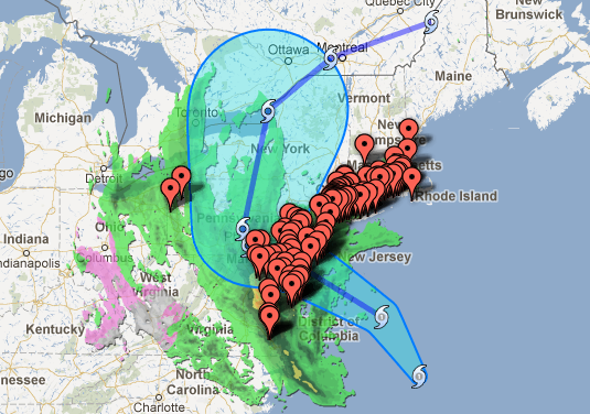
 Google Map showing Hurricane Sandy's projected path.[/caption] As Hurricane Sandy rumbles toward the East Coast, Google has decided to help out with a “Crisis Map” that includes everything from the storm’s current location and forecast track to active emergency shelters and traffic conditions. The Crisis Map draws its hurricane-path data from the NOAA-National Hurricane Center, while public alerts come courtesy of weather.gov and earthquake.usgs.gov. Thanks to Storyful, an organization that curates user-generated content from around the Web, there’s also a selection of storm-related YouTube videos and other footage. Google’s also offering a crisis map of New York City with everything from evacuation zone information (courtesy of NYC Open Data), weather information, areas of high storm surge probability, and links to various Twitter feeds and trackers, including the City of New York’s Twitter account and National Hurricane Center advisories. “If you're in Google Earth, there are some great tools available to you in there as well. By opening the [Weather] layer, you can turn on near-real-time [Clouds] and [Radar] layers, which show the storm gaining strength,” read an Oct. 26 note on the Google Earth Blog. “If you turn on the main [Places] layer in Google Earth, a small hurricane icon will appear in the center of the storm. By clicking the icon you can view news, advisories, as well as three and five day path predictions.” Google Crisis Response (a Google.org project) offers tools for first responders such as Google Public Alerts, Google Person Finder (“an open platform for individuals and organizations to let people know who they’re looking for”), and Custom Google Maps. The latter allows those first responders to update a map with hyper-local crisis information, including road closures and emergency medical stations. Google has a longtime habit of offering data tools in response to crises. Back in April 2009, for example, the search engine giant produced an app for tracking the swine flu, which at the time was infecting hundreds of people worldwide. Google Flu Trends relied on aggregated search queries to track the spread of flu across the United States (there was also a Mexico-centric version). Google has also crafted map overlays for disasters as far back as Hurricane Katrina in 2005. Given the threat presented by Sandy, it’s no surprise that Google canceled its Android-related event scheduled for Oct. 29. Image: Google
 Google Crisis Map Details Hurricane Sandy Path
[caption id="attachment_5516" align="aligncenter" width="535"]  Google Map showing Hurricane Sandy's projected path.[/caption] As Hurricane Sandy rumbles toward the East Coast, Google has decided to help out with a “Crisis Map” that includes everything from the storm’s current location and forecast track to active emergency shelters and traffic conditions. The Crisis Map draws its hurricane-path data from the NOAA-National Hurricane Center, while public alerts come courtesy of weather.gov and earthquake.usgs.gov. Thanks to Storyful, an organization that curates user-generated content from around the Web, there’s also a selection of storm-related YouTube videos and other footage. Google’s also offering a crisis map of New York City with everything from evacuation zone information (courtesy of NYC Open Data), weather information, areas of high storm surge probability, and links to various Twitter feeds and trackers, including the City of New York’s Twitter account and National Hurricane Center advisories. “If you're in Google Earth, there are some great tools available to you in there as well. By opening the [Weather] layer, you can turn on near-real-time [Clouds] and [Radar] layers, which show the storm gaining strength,” read an Oct. 26 note on the Google Earth Blog. “If you turn on the main [Places] layer in Google Earth, a small hurricane icon will appear in the center of the storm. By clicking the icon you can view news, advisories, as well as three and five day path predictions.” Google Crisis Response (a Google.org project) offers tools for first responders such as Google Public Alerts, Google Person Finder (“an open platform for individuals and organizations to let people know who they’re looking for”), and Custom Google Maps. The latter allows those first responders to update a map with hyper-local crisis information, including road closures and emergency medical stations. Google has a longtime habit of offering data tools in response to crises. Back in April 2009, for example, the search engine giant produced an app for tracking the swine flu, which at the time was infecting hundreds of people worldwide. Google Flu Trends relied on aggregated search queries to track the spread of flu across the United States (there was also a Mexico-centric version). Google has also crafted map overlays for disasters as far back as Hurricane Katrina in 2005. Given the threat presented by Sandy, it’s no surprise that Google canceled its Android-related event scheduled for Oct. 29. Image: Google
 Google Map showing Hurricane Sandy's projected path.[/caption] As Hurricane Sandy rumbles toward the East Coast, Google has decided to help out with a “Crisis Map” that includes everything from the storm’s current location and forecast track to active emergency shelters and traffic conditions. The Crisis Map draws its hurricane-path data from the NOAA-National Hurricane Center, while public alerts come courtesy of weather.gov and earthquake.usgs.gov. Thanks to Storyful, an organization that curates user-generated content from around the Web, there’s also a selection of storm-related YouTube videos and other footage. Google’s also offering a crisis map of New York City with everything from evacuation zone information (courtesy of NYC Open Data), weather information, areas of high storm surge probability, and links to various Twitter feeds and trackers, including the City of New York’s Twitter account and National Hurricane Center advisories. “If you're in Google Earth, there are some great tools available to you in there as well. By opening the [Weather] layer, you can turn on near-real-time [Clouds] and [Radar] layers, which show the storm gaining strength,” read an Oct. 26 note on the Google Earth Blog. “If you turn on the main [Places] layer in Google Earth, a small hurricane icon will appear in the center of the storm. By clicking the icon you can view news, advisories, as well as three and five day path predictions.” Google Crisis Response (a Google.org project) offers tools for first responders such as Google Public Alerts, Google Person Finder (“an open platform for individuals and organizations to let people know who they’re looking for”), and Custom Google Maps. The latter allows those first responders to update a map with hyper-local crisis information, including road closures and emergency medical stations. Google has a longtime habit of offering data tools in response to crises. Back in April 2009, for example, the search engine giant produced an app for tracking the swine flu, which at the time was infecting hundreds of people worldwide. Google Flu Trends relied on aggregated search queries to track the spread of flu across the United States (there was also a Mexico-centric version). Google has also crafted map overlays for disasters as far back as Hurricane Katrina in 2005. Given the threat presented by Sandy, it’s no surprise that Google canceled its Android-related event scheduled for Oct. 29. Image: Google
